Reading Japanese maps and marketing practices 5 - solution

Answer:
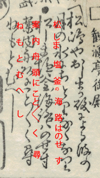
松しま塩釜の海路はのせす案内舟頭にこと/\く尋ねもとむへし
The map states that the reader should look for a guiding boatman (案内舟頭) and ask him for information about the surroundings (尋ねもとむべし), clearly implying that, by this time, there was already some kind of professional touristic guiding in the area. This recommendation is also due to the fact that there were some meisho only reachable by boat. This might be the case for a stone monument situated on a small island in the middle of Matsushima bay. The monument indicated on the map was erected in the 14th century in honor of a certain monk called Raiken (頼賢) and still stands today. The map also warns the traveler not to take the ferry crossing between Matsushima and Shiogama by mistake, which is indicated by a black line over the waters of the bay. From this kind of indications, we might infer that the map was devised as a portable guide, and that the reader was expected to follow its indications while traveling across the region.
