Heian-, Kamakura- and Muromachi-period maps

‘System of estates and imperial court land’ (shōen-kōryo-sei 荘園公領制).

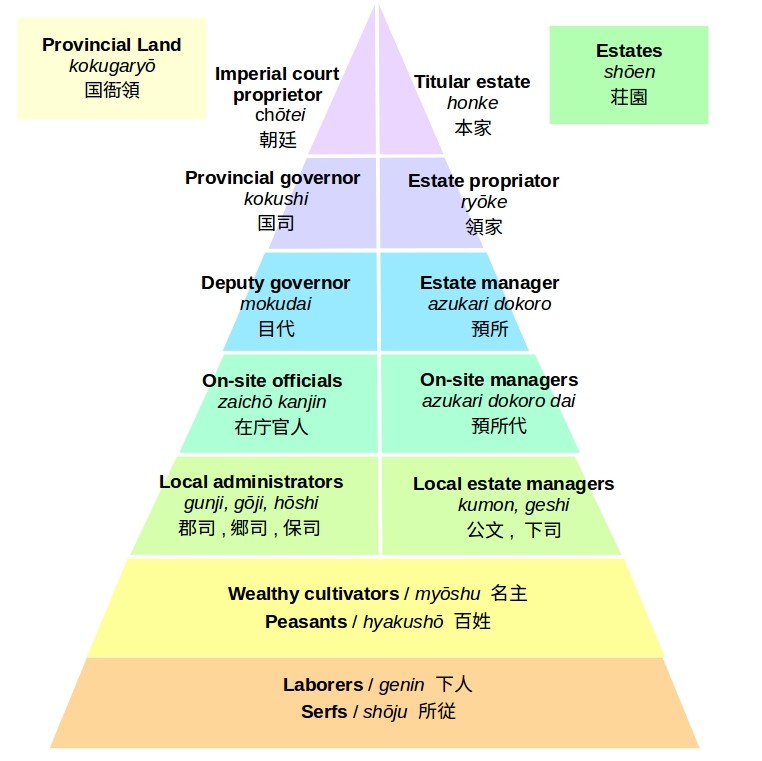
Estates (shōen 荘園), such as the ones of Tōdai temple, founded between the eighth and tenth centuries, were a result of land reclamation activities. In the eleventh century, however, there was a wave of estate foundations on already existing tax units. Estate foundations implied tax exemption and non-entry of provincial offiicals (fuyu funyū 不輸不入), and are thus an indication to the weakening of the imperial court's centralized bureaucracy, built on the Chinese model. Nevertheless, the disintegration of the ancient Japanese state did not imply the demise of the imperial court's cultural importance nor of its economic base: the founders of estates placed these under the patronage of members of the imperial family, court aristocrats and temples in the capital area. Temples in particular appear to be influential estate proprietors. But this picture needs to be modified, owing to the greater archival continuity in temple treasure houses than in the residences of official families. The latter retained income rights over former ‘provincial land’ (kokugaryō 国衙領). The period between the eleventh and fourteenth centuries has been accordingly labeled the ‘system of estates and imperial court land’ (shōen-kōryō-sei 荘園公領制). The graph to the left shows the pyramidal, all-encompassing system of land administration, according to which the elite in the capital area as well as local agents had income rights over the same land

The shifts in terms for maps and in map layouts reflect the transformations in land administration, characterizing the transition from Japan's ancient to medieval period. Twelfth-century written records refer to eighth-century ‘maps of newly reclaimed fields’ (kondenchi-zu, kaidenchi-zu) as ‘maps’ (ezu 絵図). Furthermore, so-called ‘estate maps’ (shōen ezu), produced between the twelfth and fifteenth centuries, omit the grid pattern, characteristic for earlier maps. Rather, these maps use a bird’s eye view and include pictorial elements in colour. They disclose the influence of picture stories and views of temple precincts, drawn in the same period.

Whereas estate maps carry more information than other map types, their representation of topography is inaccurate, and sometimes seems to be intentionally distorted. The logic of representation in these maps is related to the intention behind their production, namely the proof of claims: estate maps were typically drawn on the occasion of the foundation of an estate, during boundary conflicts, or conflicts over irrigation water. Therefore, Nishioka Toranosuke (1895-1970), who conducted pioneering research on estate maps in the 1930s, suggested that estate maps were to be understood as a supplement to written records, used within an admistrative or legal context.

The meaning of estate maps as weighty emblems of claims to land is suggested by a court case in 1184, involving two temples, namely Kōyasan in Kii province and Jakurakuji in Kyoto. At stake were the income rights over Ategawa no shō, an estate situated to the south-east of the Kōyasan monastery complex in Arita district of Kii Province (present-day Shimizu-chō, Wakayama prefecture). The Azuma kagami, compiled around eight decades after the conflict, has it that the founder of the Kamakura bakufu (1185–1333) himself, Minamoto no Yoritomo (1147–1199), passed a verdict in favour of Kōyasan. The chronicle describes the decision-making process, involving maps and written records:

Genryaku 1 [1184], Seventh month, 2nd day.

An emissary from the high priest of Buddhism of Jōju-in arrived last night [...] to lodge a suit against the monks of Jakuraku-ji for their encroachment on and commission of lawless acts on Ategawa Manor, an estate of Mount Kōya, in Kii Province.

The emissary presented a map of the lands of Mount Kōya, as well as documents with the seal of Kōbō Daishi [Kōbō Daishi, the posthumous name of Kūkai (d. 835), who founded Mount Kōya] affixed on them. These documents were read and explained to His Lordship by the provisional governor of Chikugo Toshikane. As His Lordship was convinced that these documents were those of Kōbō Daishi, he has issued a directive ordering the immediate cessation of outrages on the said lands […].

Azuma kagami, Book 3, English translation by Shinoda Minoru, The Founding of the Kamakura Shogunate, 1180 – 1180, with selected translations from the Azuma Kagami (New York: Columbia University Press 1960), pp. 270–271, online via the Japanese Historical Text Initiative (JHTI).

The map in question is not handed down to us, and perhaps the story altogether is an invention to represent the authority of the shogun. But the layout of estate maps confirms that maps were meant to be integrated in ‘performances’. They were likely spread and turned on the floor, allowing spectators to examine them from all sides: cardinal points and further text elements are arranged in varying directions and the pictorial elements preclude a distinct perspective view. 

Satellite picture of Nate 名手, Shimonyūya 下丹生 and Kaminyūya 上丹生 in Kinokawa city of Wakayama Prefecture.

A dispute about the use of water between Nate estate and the neighbouring Nyūnoya village of Kokawa estate in Kii Province shows the process of map-making. Nate estate was under the authority of Kōyasan and Nyūnoya village belonged to Kokawa-dera, both ancient and prestigious temples in Kii Province. The conflict was about the question which of the two streams branching off at Shii’o at the upper course of Minase river (present-day Nate river) was to be considered the main stream (north-south according to Nyūnoya, and west-east according to Nate), and hence the stream rightfully monopolised for field irrigation.

In 1241, the case was opened at the so-called Rokuhara, the law court of the Kamakura bakufu established in Kyoto after the Jōkyū war in 1221. In 1244, the Rokuhara sent envoys, who required a ‘report map’ (chūshin ezu) from both temples. Subsequently, the envoys too made a map, jointly signed by the officials of both estates. In other words, the conflict provoked the production of three maps. The Rokuhara, however, did not reach a verdict, but transferred the case to the imperial court, based on the reasoning that the case was about a boundary dispute in the Western provinces, which were under the authority of the imperial court. The imperial court reached a verdict in 1250. The verdict had it that because the three maps greatly differed, a new survey was deemed appropriate. However, because the report map of Kokawa-dera and the survey map of the envoys of the Rokuhara contained similarities, Nyūnoya village was to be considered the victorious party. The outcome of the conflict suggests that in effect none of the three maps were precise cartographic projects. None of the three maps has been handed down to us. 

To gain an impression of the topographical conditions, triggering the conflict, a present-day satellite picture offers some clues. It shows Nate 名手, Shimonyūya (Lower Nyūya 下丹生) and Kaminyūya (Upper Nyūya 上丹生), located within present-day Kinokawa city of Wakayama prefecture. Nate river divides Nate from the other two villages, before flowing into the prefecture’s main river, Kinokawa 紀の川. But you can also tell that the courses of rivers have been regulated, and rivers have been overbuilt. The latter is suggested by the interruption of streams or the tree alleys respectively, which suggest underground water.

.

‘Map of Inoue Main estate in Kii Province’ (Kii no kuni Inoue honshō ezu 紀伊国井上本庄絵図), ink and colours on paper, c. late fourteenth century, 65.4 x 53.1 cm, important cultural heritage, Zuishin'in, Kyoto Institute, Library and Archives (Kyōto furitsu Kyōtogaku rekisaikan 京都府立京都学・歴彩館), URL: http://bunka.nii.ac.jp/heritages/detail/429076

A map of Inoue main estate of Kii Province (present-day western part of Kokawa-chō, Kaga district, Wakayama prefecture) shows the details, typically contained in estate maps. The map likely dates from the Muromachi period (1336–1573). It is painted in ink and light greenish and brownish colours. Since there is a dearth of written records, offering a clue about the intention behind the production of the map, historians have forwarded different explanations: first, the foundation of the estate, which would imply a date of production in the late twelfth century and thus is unlikely; second, increasing pressure from the local elite, that is, Kokawa-dera or local warrior families; and finally a property dispute between Kokawa-dera and the Zuishin-in in Kyoto in 1393. The latter temple is the current owner of the map.

Like modern maps, the map has a north orientation. But this is a coincidence, since estate maps display a variety of orientations: multi-directional, north, east, south or west respectively. The orientation is likely due to the particular topography of the locality. Inoue estate was situated to the north of Yoshino river (present-day Kinokawa), and was adjacent to Kokawa estate to the east and Inoue new estate (Inoue shinshō) to the west. The map indicates the names of these estates, each divided by boundary lines from north to south. Furthermore, the map shows streams, hills, forests, village settlements, temples and shrines, fields and ponds within the estate. The inscribed names give details: Shino river flows through the upper half of the estate from the north-west, is renamed into Fukeda river further south-east and then into Kado river beyond the south-eastern boundary of the estate (present-day Matsui river), before entering into Kinokawa. Furthermore, we find the names of 5 settlements and details on the type of fields, including ‘tenant fields’ (uke-ta) and ‘paddy and dry fields’ (tahata). The ponds, 15 in total, are drawn as circles in beige, and also have their names inscribed. These water reservoirs were used for field irrigation by the villages of the estate. The temples and shrines, of which we find 9 names, were likely political and cultural centers of the local village communities, or marked the boundaries to unfamiliar mountain land respectively. In sum, the map, while giving evidence to the estate proprietor’s authority, also offers a glimpse into the social and economic life within the estate.

.

‘Map of Ito, Naga, Nagusa and Ama districts’ (Ito gun, Naga gun, Nagusa gun, Ama gun 伊都郡那賀郡名草郡海部郡), Wakayama University Library, URL: https://trc-adeac.trc.co.jp/Html/ImageView/3071055100/3071055100200020/ezu7/

An Edo-period map in the collection of Wakayama University Library shows Ito, Naga, Nagusa and Ama districts of Kii Province. Several villages in the north-east area of Naga district are those, which appear in the records and maps in the context of the conflicts in Kii Province during the Kamakura and Muromachi periods: Nogami village 野上村 (former Nate estate), Shimonyūnoya 下丹生谷村 and Kamiyūnoya villages 上丹生谷村 (former Kokawa estate), and Kitanagata village 北長田 (former Inoue main estate).

The conspicuous reservoirs, which are drawn on the map of Inoue main estate, have disappeared. They have been substituted by the Odai irrigation channel, guaranteeing continuous water supply from Kinokawa during the Edo period. The map, however, also suggests that in the Edo period, there were still plentiful above-ground streams, flowing from the mountains into Kinokawa. These streams, which fragment the area into land parcels from north to south explain the high number of estates as well as the conflicts about irrigation water in the area during the medieval period. Whereas the district map held by Wakayama University Library offers clues on the topographical conditions, shaping the economy and society of medieval estates, the map also indicates that by the Edo period the former estate boundaries had become meaningless. 

Plan of Tarumi no shō in Settsu Province (Settsu no kuni Tarumi no shō zashizu 摂津国垂水荘差図), 1463 ( tenth month of Kanshō 4), 67.4 x 54.5 cm, ‘Documents of hundred boxes of the Tōji’ (Tōji hyakugō monjo).

Image from: The Hyakugo Archives WEB (Kyoto Institute, Library and Archives (Rekisaikan), URL: http://hyakugo.kyoto.jp/contents/detail.php?id=8522&p=2

In the late Muromachi (1336–1573), or Sengoku period (1477–1573), rough ‘plans’ (sashizu 差図) replaced picture-like maps (ezu 絵図). The trend is reflected in a plan of Tarumi estate in Settsu Province (or rather a part of the estate, agreeing with present-day Esaka-chō and Toyotsu-chō in Suita city, Osaka Prefecture), dated to 1463 and handed down to us in the collection of documents of Tōji, an ancient monastery complex in Kyoto. The plan still includes pictorial elements, which are by no means merely decorative. Rather, like in earlier estate maps, an occasional tree, a shrine or a ship indicate a landmark, a boundary or a ferry crossing. Nevertheless, there is a reduction of pictorial elements compared to earlier estate maps. The emphasis is on arable fields and irrigation structures (kangai 灌漑) of villages (gōson 郷村). The plan of Tarumi estate indicates the intensification of land cultivation due to the development of irrigation systems and the use of fertilizers. Furthermore, the plan suggests that Tōji officials conducted cadastral surveys to calculate fixed taxes instead of directly overseeing agricultural processes.

The fifteenth- and sixteenth-century plans of partial agricultural areas rather than estates in their totality reflect the break-up of the all-encompassing, multi-layered system of land administration, and the medieval state, for which it stood. In fact, by the time the map was drawn, Tarumi no shō did not yield income to Tōji anymore, the map thus mirroring empty claims. The loss of control of the elite in the capital area over remote estates occured in parallel to the emergence of semi-autonomous villages led by local warriors, who were retainers of daimyo. The latter had been originally appointed by the bakufu to oversee the provinces, but emerged as powerful territorial lords themselves.