Reading Japanese maps and marketing practices 4 - introduction
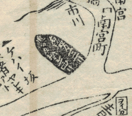
Now that we have begun our journey on the map, let’s leave Miyagino, cross the bridge and take the main road to the sea. This road is indicated on the map by the faint words 塩カマ松シマ本カイ道 over it. After crossing the bridge in Imaichi-chō (今市町) and several meisho, there is a point at which the path splits in two. This place is illustrated on the map by a black oiwake-ishi or dividing stone. It indicates that the right path leads to Shiogama and the left path leads to Matsushima. It also indicates the distance to these places in ri (里), a unit of distance equivalent to approximately 3,9 km.