Edo-period maps

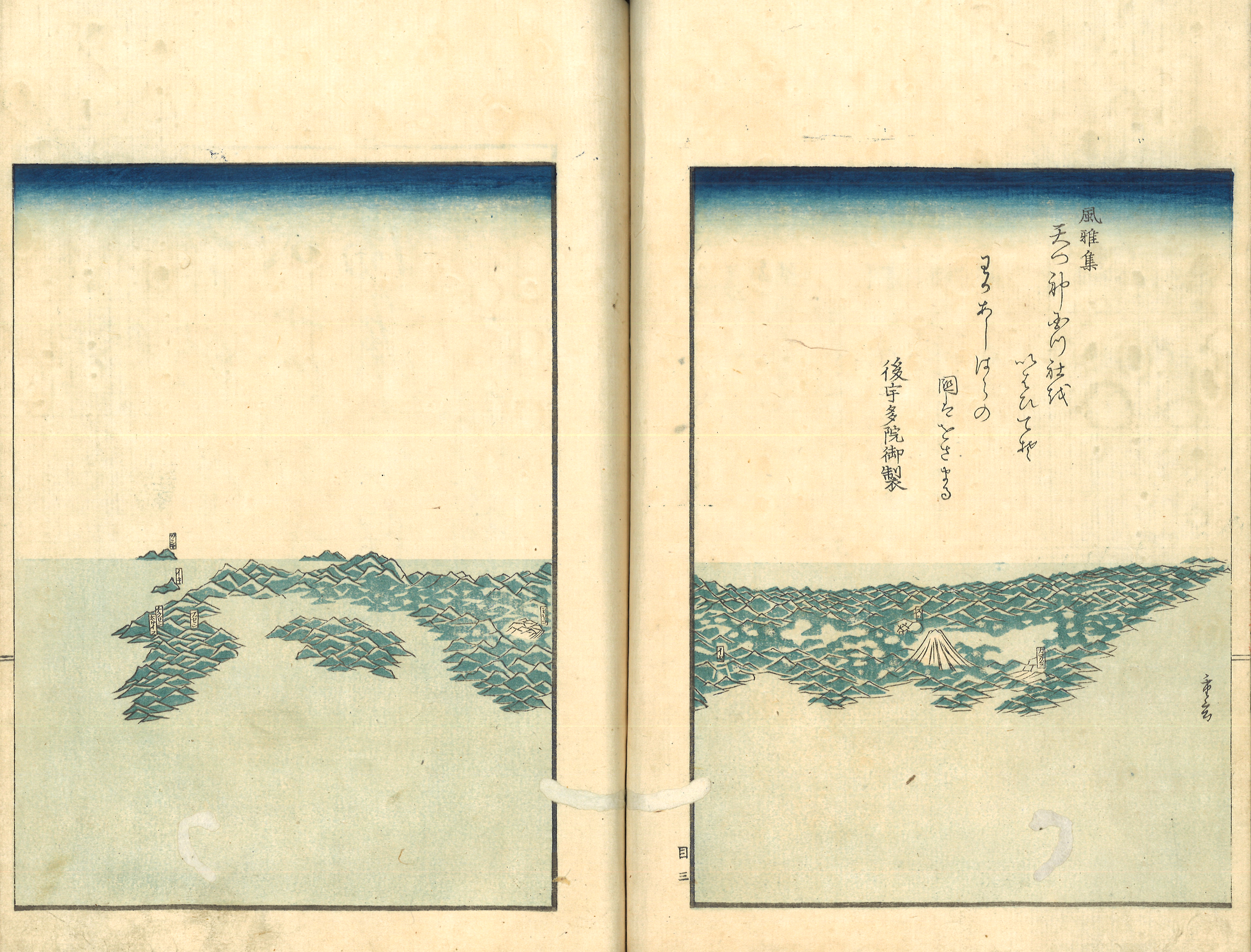
Bird’s eye-view of Japan, in Ishikawa Masumi, Mōzokuki, preface 1856 (Nagoya: Eirakuya Tōshirō, 1858), vol. 1; author's collection.

The text in the top right has it: ‘From the Fūgashū: the deities from heaven have hallowed the earth shrine, they rule over Japan, a poem by Emperor Gouda.’ (Fūgashū: amatsukami kunitsuyashiro wo ihahiteso, wakaashiharano kuniha wosamaru, Gouda-in gyosei).

Sugimoto Fumiko has coined the term ‘mapped society’ to characterize the Edo-period (1603–1868). According to Sugimoto, ‘[…] this period of Japan’s history has left us with a dizzying diversity of maps, each one made with particular goals in mind.’ Furthermore, Peter Kornicki has referred to the importance of maps within Edo-period print culture. According to him, commercially published maps functioned like books not only in terms of materiality, since they were folded to standard book formats and equipped with two covers, but because of the informations they presented:

[T]hey became for the Japanese reading public the primary means of envisioning spaces, from the city to the province, to the whole of Japan and even the world. These published maps testify to the spread of spatial literacy maps call for and to the increasing functional significance of maps in Tokugawa society. 

Kornicki, Peter, The Book in Japan: A Cultural History from the Beginnings to the Nineteenth Century (Leiden, Boston and Köln: Brill, 1998), p. 60–61.

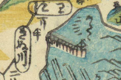
Finally, Mary Elizabeth Berry has indicated that maps were well available in the Edo-period ‘information library’. The latter term refers to Benedict Anderson's classical idea of print capitalism as a pre-condition to a shared sense of time and space that characterizes modern nations. A mid-nineteenth-century bird's eye-view of Japan reflects the spatial imaginaries circulated through maps. Recognizable are Japan's main islands, Honshū, Shikoku and Kyūshū. Three smaller islands, identified as Iki, Tsushima and Oki islands, are at the western horizon. To the east, Mount Fuji with a snow summit rises from the green relief-like design of the archipelago. The southern tip of Ezo (present-day Hokkaido) is visible to the north of Honshū. Yet, the shared notion of ‘Japan’, created by Edo-period maps, is still quite different from modern representations of the nation. This is suggested by the map genres, drawing and printing techniques and codes, which are presented in the following sections.

‘General map of Japan of the Keichō era’ [1596–1615] (Keichō Nihon-sōzu 慶長日本総図), early Edo period, manuscript, ink and colours, 370 x 434 cm, held by the National Diet Library Toyko, URL: http://dl.ndl.go.jp/info:ndljp/pid/1286203?__lang=en

The bakufu ordered daimyo to submit provincial maps (kuniezu 国絵図) together with village cadasters (gōchō 郷帳) at five occasions, around 1605 (Keichō era), 1633 (Kan'ei era), between 1644–1656 (Shōhō era), 1697–1702 (Genroku era) and 1835–1838 (Tenpo era) (see the National Archives of Japan Digital Archive). The geographical information, which resulted from these general surveys, was integrated in comprehensive maps of the country. A comparison between the maps of each survey reveals a shifting representation of Japan's coastlines. Territorial boundaries, which characterize modern nations, were thus not yet as clearly defined in the Edo period, as they appear to be in singular maps.

The so-called ‘General map of Japan of the Keichō era’ (1596–1615) was formerly believed to date from the first bakufu survey of 1605. The hand-drawn, colored map includes the names of rivers, roads, and waterways, while also referring to the boundaries between domains, towns and villages. Next to each castle town, represented as white squares, the lord of the castle, that is, the daimyo, and his stipend in rice measurement (kokudaka) is indicated. The names of daimyo agree with the situation of 1654, but the distribution of castles with a state of about ten years earlier. The map still displays several mismeasurements: Dewa and Mutsu provinces in the north-east are too small and short, and Mutsu Bay is too shallow; the island of Shikoku has the shape of a rectangle and Kyushu's central area is constricted. As a new feature, the map of the third survey of the Shōhō era (of which the original was destroyed by fire in 1873) includes Ezo. The map of the fourth survey of the Genroku era has been lost, but two copies are believed to reproduce it (one of which is handed down to us at the Meiji University Library). The map is sought to be less reliable than the Shōhō-era map. But it is the first map iniated by the bakufu, which shows the complete Ryukyuan island chain as well as the southern coast of Korea.

.

‘Detailed itinerary map of great Japan’ (Shinpan Nihonkoku ōezu 新板日本国大絵図), c. 1687, woodcut, colour, 68 x 166 cm, Engelbert Kaempfer collection, shelfmark: Or.75.f.13(2), The British Library, usage terms: Public Domain.

Note the inscription in Latin ‘matsumai vulgo jeso matsumai’ (Matsumae, commonly Ezo Matsumae), written next to the Japanese Matsumae 松前, in the top right of the map. Matsumae Domain is represented here as a small island between Honshu and Hokkaido (Ezo). Later so-called ‘Ryūsen maps’ correct this representation.

Marcia Yonemoto has indicated that the artist Ishikawa Ryūsen (active, 1687–1713) ‘vernacularized’ spatial knowledge, by producing a first map of Japan in print in 1687. New editions followed thereafter. So-called ‘Ryūsen maps’ (Ryūsen-zu 流宣図) follow the layout of maps iniated by the bakufu, such as the ‘General map of Japan of the Keichō era’. But they are suited to the tastes and needs of a popular audience: they are greatly reduced in size; moreover, their design is ornamental and practical at once, by including miniature pictures of mountains, buildings, waves, ships as well as referring to stations and distances (editions held by Meiji University Library, and Kyoto University Museum).

A map, with the title ‘New edition of the great map of Japan’ (Shinpan Nihonkoku ōezu 新板日本国大絵図) from the collection of Engelbert Kaempfer (1651–1716) is presently held by the British Library. The shape of the Japanese archipelago is reminiscent of the edition, held by the Kyoto University Museum, dated to 1689: Matsumae Domain is shown as a separate island, Honshu and Shikoku are elongated, and Kyushu is compressed - in later editions Matsumae is correctly shown on Ezo (present-day Hokkaido), whereas the Japanese islands are inflated so that the sea takes up a minimum of the sheet. In contrast to the map at the Kyoto University Museum, however, the map at the British Library is less colorful: whereas the sea, mountains and the islands and foreign lands surrounding the Japanese three main islands are colored in blue, beige, brown, lime green and fir green, the main islands are left blank. Ryūsen was active, when woodblock prints were still hand-colored, explaining these variations. The map at the British Library also omits pictorial and ornamental elements, such as ships or waves, and has only one panel with written information, in contrast to three or more in later editions. The panel includes a legend, according to which squares are used for castle towns and circles for stations (shuku[eki] 宿), and a list of provinces and their revenues. In the map, one reads the names of provinces, the number of districts per province, the name of daimyo and their revenue. According to the British Library catalogue, the daimyo names and revenues agree with a state of c. 1686, corroborating the idea that the map is an early edition.

According to Yonemoto, in turn, Kaempfer popularized Ryūsen's representation of Japan in Europe, by adopting a Ryūsen map in his History of Japan, published in English in 1727 (online via the Central Library Zurich). In Japan, Ryūsen maps were only supplanted by Nagakubo Sekisui's (1717–1801) ‘Revised complete map of Japan and earth distances’ (Kaisei Nihon yochi rotei zenzu 改正日本輿地路程全図), first published in 1779. Sekisui's map was the first map in print, placing Japan on a grid according to a fixed scale (online via the Library of Congress). In contrast to Ryūsen maps, Sekisui's map includes more place names, uses more pronounced contour lines and colors, and applies shadings to coasts and mountain reliefs. Furthermore, as indicated by Matsui Yōko, ‘decorative elements [are] deemphasized and travel and political information [is] stripped out altogether.’ 

‘Old Map of Toba Castle’ (Toba jōkaku kozu 鳥羽城廓古図), in Nihon kojō ezu: Tōkaidō no bu  日本古城絵図: 東海道之部, manuscript, ink and colours, Edo period, National Diet Library (http://dl.ndl.go.jp/info:ndljp/pid/1286293?tocOpened=1)

Maps of Japan, be it the hand-drawn maps of the bakufu or the printed Ryūsen maps, provided information on castle towns, namely their location, the name of the lord of the castle and the amount of his revenue. The maps mirror the significance of castles in the cultural imagination and administrative system of the Tokugawa state, and as social and economic centers of domains – a process promoted by the ‘one castle per domain edict’ (ikkoku ichijō rei) of the first Tokugawa shogun Ieyasu (1543–1616) in 1615, which limited the castles of daimyo to one per domain. In 1644, during the third shogunal survey, the bakufu ordered daimyo to submit charts of their castles, the so-called ‘Shōhō-era castle charts’ (Shōhō shiro ezu), along with the required provincial maps and village cadasters (63 sheets held and digitized by the National Archives of Japan). During the fourth survey of the Genroku era (1688–1704), several daimyo submitted castle charts on their own initiative.

There were several motives for the making of castle charts. First, castle charts were required for the construction and repair of castles. An illustration with the caption ‘Intersection’ (shichi hito kaihō 四知一開方) in the ‘Instructions to measure the earth’ (Ryōchi shinan 量地指南), vol. 3, of 1733 by Murai Masahiro 村井昌弘 (1693–1759) shows the measurement of castle walls on the basis of trigonometry (see the edition held at the Waseda University Library). Masahiro opened a military school in Anotsu in Ise Province (present-day Mie Prefecture), so the irregular walls of the local Tsu castle might have served as a model for his illustration – since firearms were negligible for tactical considerations, castle walls were variable, comprising circle, square, spiral, triangle and star-shaped layouts. Second, the importance of charts for construction projects also explains why daimyo submitted castle charts to the shogun, namely to request permission to repair their castles. Third, castle charts, that provided access to sensitive military information, were an instrument for the bakufu to reinforce its authority over daimyo.

Finally, despite containing information on the defense systems of daimyo, castle charts were not as secrete as one would expect them to be: castle charts were exchanged among daimyo and their retainers for military education. In the mid-eighteenth century, the military expert Yamagata Daini (1725–1767) produced the ‘Record on explanations and charts of daimyo [castles]’ (Shuzu Gōketsuki 主図合結記), with 144 castle charts in five scrolls. His record served as a model for further hand-drawn copies of castle charts. Daimyo were able to acquire impressive collections over the course of time: 355 sheets, covering 220 castles and united under the title ‘Charts of Japan's old castles’ (Nihon kojō ezu 日本古城絵図), are handed down to us by the Inagaki family, daimyo of Toba Domain (present-day Mie Prefecture) from 1725 onwards. The map to the left shows the sheet with the chart of Toba castle, the so-called ‘castle at the sea’ (umi no shiro) from this collection.

‘Preliminary remarks on colors and figures’ (saishoku hanrei 彩色凡例, zukei hanrei 図形凡例), scroll 1, and ‘Toba castle’, scroll 2, of Yamagata Daini 山縣大貮, Shuzu Gōketsuki 主図合結之記, hand-colored manuscript, 5 scrolls, Kyoto University Library, URL: https://rmda.kulib.kyoto-u.ac.jp/item/rb00013866 

In 2019, a chart of Toba castle was discovered among 74 castle charts included in the ‘Very secrete castle charts of the various provinces’ (Gokuhi shokoku shiro zu 極秘諸国城図). A citizen from a former retainer family of Matsue Domain had donated the collection to Matsue city, Shimane Prefecture, in 1953. The chart is sought to be the oldest known chart of Toba castle. Like in provincial maps (kuniezu), colors and pictorial elements serve to demark different areas in the chart.

The ‘preliminary remarks on colors and figures’, that is, the legend of the eighteenth-century Shuzu Gōketsuki by Yamagata Daini helps to decode the meaning of colors and pictorial elements (held by the Kyoto University library) in castle charts: Daini uses yellow for roads, blue for waterways, green for banks and cliffs, red for dry ditches and valleys, blank spaces for samurai residences and brown for townsmen dwellings; black squares refer to watchtowers, black lines to stone walls and main ditches, and grey lines to side ditches; roof structures indicate gates etc.The chart of Toba castle in Daini's compilation (held by the Kyoto University library) includes captions to designate the keep (tenshu), the innermost compound (honmaru), and the second compound (ni no maru). The chart also shows the town area adjacent to the castle, and names the landing stage (funairi 舟入) (right) and ship warehouse (funakura 舟蔵) (left). Samurai residential areas, left blank, are located to the north-west (right edge) and townsmen dwellings, colored in brown, to the south-west (top center). 

The wide circulation of castle charts among daimyo and their retainers and the shared codes in maps gives insight into the extent of networks, uniting the elite throughout Japan. Again the boundaries, created through colors in castle charts, refers to the status-oriented style of life of the elite in the Edo period.

.

‘Complete map of Tokyo’ (Tōkei on-ezu, zen 東京御絵図 全) (Tōkei [Tokyo]: Yoshidaya Bunzaburō, 1869), woodcut, color, 70 x 96 cm, Japan Library, Institute of Asian and Oriental Studies, University of Zurich.

Castle charts can be considered city plans. However, they were not usually converted into print, indicating that they were reserved for the ruling elite. In contrast, maps of Kyoto, Osaka and Edo assumed a prominent place on the print market during the Edo period. These three major cities were also publishing centers. Kyoto publishers first took the lead: the ‘record of the capital’ (miyako-ki 都記) (held by the Kyoto University Library) is considered the earliest city map in print, and was published in the 1620s. Maps, which were based on actual surveys, however, first covered Edo. After the Great Meireki fire of 1657, which destroyed the greater part of Edo, the bakufu commissioned the strategist Hōjō Ujinaga 北条氏長 (1609–1670) to survey the city. Permission to publish the maps was granted by the bakufu, and Ochikochi Dōin 遠近道印 (1628–?), the artist involved in Ujinaga's survey, published the maps as the ‘New edition of the great map of Edo’ (Shinpan Edo ō-ezu 新板江戸大絵図) (held by the National Diet Library Tokyo) and the four ‘New editions of the outer maps of Edo’ (Shinpan Edo gai-ezu 新板江戸外絵図) (held by the National Diet Library Tokyo) between 1670 and 1673. Taken together, the maps are known as the ‘five maps of the Kanbun era’ (1661–1673) (Kanbun gomai zu 寛文五枚図). Because the five maps are not in the same scale and areas are disconnected, Dōin subsequently united the five maps in one sheet.

Though later maps are more colorful and update information about the cityscape, Dōin's integral map served as a model to single-sheet Edo maps until the latter part of the nineteenth century. A map, published one year after the Meiji Restauration, with the title ‘Complete map of Tōkei’ (Tōkei on’ezu, zen) – what is now Tōkyō was pronounced Tōkei from around 1868 to 1889 – is still based on Dōin-type maps: its layout is comparable to the ‘Scaled great map of Edo’ (Bunken Edo ō-ezu 分見江戸大絵図), published in 1862 (held by the Waseda University Library); what is more, the map still refers to the shogunal ‘castle’ (o-shiro) and residences of daimyo within the castle area that unwounds in a clockwise direction into the city. 

.

‘Sketch of Edo’ (Edo ryakuzu 江戸略図), added to the ‘Precise Record of travel [routes] and distances’ (Dai Nihon dōchū kōtei saikenki 大日本道中行程細見記)(left section), [Shinsaibashiminami (Osaka): Kichimonjiya Ichibē 吉文字屋市兵衛, c. 1770s–1830s], woodcut, color, University of Zurich, Japan Library.

Unlike the ornamental folding screens with views of Kyoto, Osaka or Edo that reach back to fifteenth and sixteenth centuries, commercially published maps of these cities were widely circulated. As publishing grew more competitive, the number of print runs and editions of maps increased. From the 1770s, the development of woodblock printing processes allowed to easily add colors. Like the used printing techniques, the used material, namely thin rice paper, indicates that maps were produced cheaply and in large volumes. Formats became variable, including apart from one-sheet maps, leporello-folded maps (orihon 折本), booklets that included several maps, such as the Edo hōgaku anken zu 江戸方角安見図 (held by the National Diet Library Tokyo) and collections of small-scale pocket-sized separate maps (kiriezu 切絵図) (held by the National Diet Library Tokyo and presented in relation to present-day Tokyo). By 1859, more than a dozen different maps of Edo were being published annually.

Whereas the castle of the shoguns in Edo, or the Imperial palace (dairi) in Kyoto were left blank in these maps, they contained detailed information about streets, inns, temples, and officials' housings. Leading publishers, such as Suharaya Mohee 須原屋茂兵衛, reacted flexibly to urban changes, by altering details in printing block sets, such as newly built housing areas and the names of officials. Suharaya Mohee is also known as the publisher of so-called ‘military mirrors’ (bukan 武鑑). The latter assumed the function of directories, by including the names, roosters and crests of daimyo and their retainers and in the course of the nineteenth century also the names of townspeople in the service of the bakufu. Military mirrors and maps of Edo were thus meant to be read together, the first allowing to identify people and the second to locate their residences in Edo. Maps of Edo were also integrated as addendum into road maps, as seen in the ‘Precise Record of travel [routes] and distances’ (Dai Nihon dōchū kōtei saikenki) shown to the left, hence referring to the popularity of Edo as a travel destination. 

.

‘Detailed itinerary map of great Japan’ (Dai Nihon saiken dōchū zukan 大日本細見道中図鑑), woodcut, color, c. 1850, University of Zurich, Japan Library.

Already Engelbert Kaempfer, who stayed in Japan between 1690 and 1692, notes the throng of people travelling on Japan’s roads. The five main roads in the Edo period were the Tōkaidō, Nakasendō, Nikkō kaidō, Kōshū kaidō and Ōshū kaidō. ‘Stations’ (shukueki 宿駅) were established in about a day’s march distance, where travelers found lodging. For instance, along the Tōkaidō, leading from Edo to Kyoto, there were 53 stations. ‘Barriers’ (sekisho 関所) not only guaranteed travelers’s safety but also allowed to oversee the movement of people.

Travel culture during the Edo period was closely related to Japan’s political system. The bakufu upheld the ‘alternate attendance’ (sankin kōtai 参勤交代) between the 1635 and 1862, which implied the regular residence of daimyo and the permanent residence of daimyo wives and children in Edo. Daimyo and samurai in their service thus regularly traveled to and from Edo.Their style of life promoted the further movement of people and goods under the authorities' supervision: commoners, who wished to travel, had to apply for a travel permit at the temple or shrine, where they were registered. The permit clarified the aim, course and duration of the travel and was to be shown at barriers and stations. Commoners were in particular permitted to undertake pilgrimages, a popular destination being the Shrines of Ise. En route, travelers had the occasion to visit famous places (meisho 名所) and at the final destination not only shrines but also entertainment areas.

Despite the ideal of social and geographical stability, propagated by the bakufu, by the early nineteenth century political and economic shifts reinforced the mobility of all status groups. Notwithstanding the bakufu's directives, according to which the wifes and children of daimyo were to permanently reside in Edo, even daimyo wifes travelled frequently to their home provinces by the early nineteenth century. This is what we learn from Philipp Franz von Siebold's ‘Journey to the Court of the Shogun’ (entries of April 5 and 6, 1826) who reports an encounter en route with a daimyo concubine. Also, commoner women traveled to Edo from their home provinces in search of a better livelihood.

Travel through politics, leisure and economy created a market for literary ‘travel accounts’ (kikōbun 紀行文), practical guidebooks and ‘travel maps’ (dōchūzu 道中図). By the early nineteenth century, there were printed maps of famous places, such as temples, shrines or hot springs, maps of pilgrimage routes, maps of guild inns along a given route and maps of particular main roads. Finally, there were maps covering the entire country. These informed about land and sea routes, distances, stations, prices for inns and details on famous places to visit. Travel maps were usually of the folded variety. Designs were variable, ranging from diagrammatic designs, which represented roads in parallel lines (like present-day subway plans) but at times were interspersed with pictures, to conformal designs, which showed roads and towns against the silhouette of the Japanese archipelago.

futami

Married couple rocks (J. meoto iwa 夫婦岩) at ‘Futami ふたみ’ (二見), detail from the ‘Detailed itinerary map of great Japan’ (Dai Nihon saiken dōchū zukan 大日本細見道中図鑑), woodcut, color, c. 1850, University of Zurich, Japan Library. (View in the whole map: https://j-images.ch/icp/index.html?curation=https://mp.ex.nii.ac.jp/api/curation/json/615ffc54-24fb-4f05-9f88-d3e72133e8bf&lang=en)

Floating hall of the Mangetsu temple (J. Mangetsuji ukimidō 満月寺浮御堂) at ‘Katata かたた’ (堅田), detail from the ‘Detailed itinerary map of great Japan’ (Dai Nihon saiken dōchū zukan 大日本細見道中図鑑), woodcut, color, c. 1850, University of Zurich, Japan Library. (View in the whole map: https://j-images.ch/icp/index.html?curation=https://mp.ex.nii.ac.jp/api/curation/json/615ffc54-24fb-4f05-9f88-d3e72133e8bf&pos=2&lang=en)

The Tōkaidō was a popular subject of travel maps. An example is the ‘scaled map of the Tōkaidō’ (Tōkaidō bunkan ezu 東海道分間絵図) in 5 volumes of 1690 (held by the National Diet Library Tokyo). Ochikochi Dōin 遠近道印, whom we have met as the artist of the first printed maps of Edo, is indicated as the author. The road’s distances are rendered in an accurate scale and cardinal directions, drawn on each sheet, indicate bends in roads. The map likely relies on the survey of provincial roads of 1651, conducted under Dōin's superior Hōjō Ujinaga. Despite its practical usability, the map reminds of picture scrolls: its design is divided into a fore- and background, the road is crowded with travelers and framed by hamlets and farmers, the sea shows fishing boats, and trees and mountains complete the landscape. The map thereby follows the model of the earliest travel map in print, the Tokaidō itinerary map (Tōkaidō michiyuki no zu 東海道道行之図) of the Kanbun era (1661–1773) (held by the Kobe City Museum). 

A further travel map, with the title ‘Precise travel atlas of Great-Japan’ (Dai Nihon saiken dōchū zukan 大日本細見道中図鑑) dates from the mid-nineteenth century. The writing on the lavish cover, with a travel picture in colors in the tradition of late-Edo-period colored prints, reveals that the map shows important roads, sightseeing and pilgrimage routes and that it is complemented by a panel with a list of charges and inns. According to the map legend, castle towns are shown as yellow rectangles, stations as white cartouches, province names as salmon cartouches, provincial borders as black triangles, famous temples and shrines as red circles, ‘temples that issue amulets’ (fudasho 札所) on Shikoku as smaller salmon rectangles, and temples that issue amulets in the Western provinces as larger salmon rectangles, barriers and guard houses as gates, dotted lines as sea routes, roads of the ‘five central provinces and seven greater areas’ (Goki Shichidō 五畿七道) in salmon, pilgrimage routes in white and tours through Yamato in black.

Pictorial elements, such as green and yellow mountain chains, blue rivers shaded with lines, and lakes and the sea with waves, indicate the terrain. Further pictorial elements guide the viewer through the map: we find, for instance, a picture of the married couple rocks at ‘Futami’ close to the Shrines of Ise in Shima province, or the floating temple hall at ‘Katata’ at the shores of lake Biwako. In summary, pictures in travel maps are not only inspired by travel literature and art, but also transmit practical information on the natural and administrative geography, and on travel destinations.