Map pictures
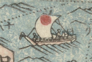
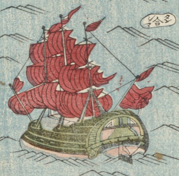
A japanese ship (top) and a Dutch ship (bottom). Image sections from 'Detailed itinerary map of great Japan'.
Solution 2
There are five smaller sailing boats and two larger ships, one equipped with two masts and one with three respectively. You may specify them further, by comparing them for instance with the ships in the ‘map of the world’ (bankoku sōzu) (held by the National Diet Library Tokyo). As the captions in this latter map suggest, it shows from the top right in clockwise direction: a ‘Great-Ming’, ‘Japanese’, ‘Southern Barbarian’ (nanban) and a ‘Dutch ship’.
The five smaller sailing boats in our travel map are obviously Japanese coasters. Again, the junk, sailing between Iki and Tsushima, ressembles the ‘Southern Barbarian ship’ in the ‘map of the world’. The shape of the ship, with two masts and sails folded crosswise, is also similar to pictures of ‘red seal ships’ (shuin-sen), which conducted trade between Nagasaki and South East Asian ports in the early seventeenth century. But in the mid-nineteenth century, neither did Portuguese nor Spanish ships sail to Japanese coasts, nor was the red seal system in effect anymore. The ship refers to the trade, conducted between Tsushima domain and Korea during the Edo period. Finally, the three-masted ship, about to enter Nagasaki, is a more ornamental version of the ‘Dutch ship’ in the ‘map of the world’. Both are in the pictorial tradition of frigates in European early modern maps, such as in the Iaponiae nova descriptio (held by the Bibliothèque nationale de France). If you want to learn more about the different ships, sailing on Asian seas in the early modern period, visit the database of pictures and maps of the Museum of Maritime Science.
In summary, the five Japanese coasters mark inland sea routes, and the Dutch frigate about to enter Nagasaki, and the junk sailing between Iki and Tsushima mark foreign sea routes. A closer look at pictures in maps thus reveals their importance as codes: they are not only ornamental, but like in the case of our travel map reveal notions of the outside world in the Edo period.