Nara-period maps

The earliest written record, referring to map-making in Japan, is the ‘Chronicles of Japan’ (Nihon shoki, also Nihongi) of 720. It quotes an imperial edict of 646 (Taika 2), which orders the examination of provincial boundaries and the preparation of maps. According to the same chronicle, in the 10th year of the reign of Emperor Tenmu, that is, in 681, a map of Tanegashima and in the 13th year a map of Shinano province were presented at the imperial court. Furthermore, according to the ‘Chronicles of Japan, continued’ (Shoku Nihongi), in 713 (Wadō 6) Empress Genmei (661–771) ordered the compilation of provincial gazetteers (fudoki), which were completed over the next twenty years. These gazetteers are said to have recorded the geography, history and produce of some 48 provinces.

The making of maps and the compilation of gazetteers both reflect the effort of the imperial court to gain an overview of the Japanese archipelago. The aim was to establish the so-called ‘rice field allotment system’ (handen shujū hō) that served to consolidate the authority of the imperial court according to the Chinese state model. The enforcement of this system, however, was short-lived, if we want to follow archival evidence. None of the ancient ‘provincial maps’ (koku-zu) and merely 5 partly fragmented provincial gazetteers have been handed down to us.

Map of Japan’ (Nihon koku no zu 日本國の圖), Gyōki map, calligrahy, colours, ca. 1656 (Meireki 2), Meiji University Library, Ashida Map Collection, URL: http://www.lib.meiji.ac.jp/perl/exhibit/ex_search_detail?detail_sea_param=9,105,0,b

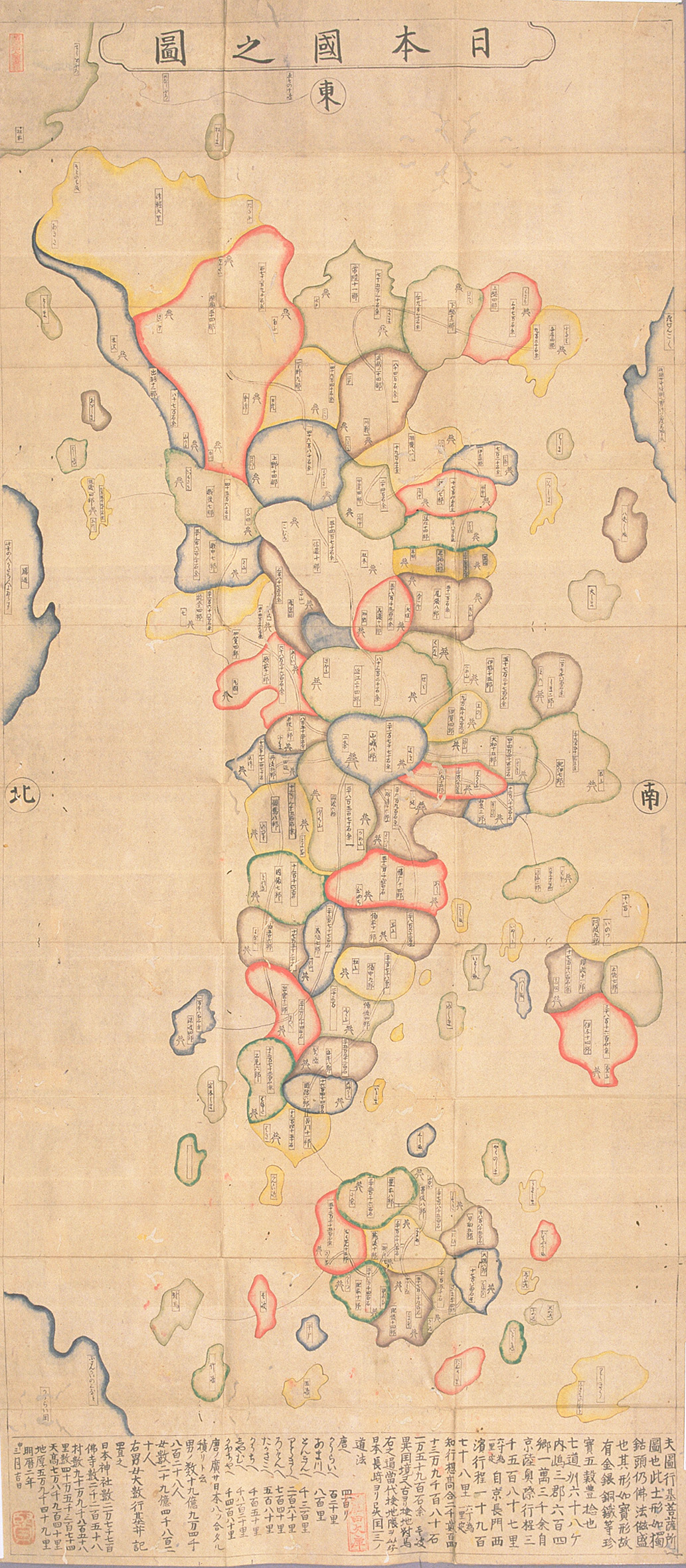
A map type, reflecting the birth of the ancient Japanese state, is the so-called ‘Gyōki map’ (Gyōki-zu 行基図). Gyōki maps can be regarded as the visualization of the sum of information, which the imperial court collected from the provinces. As a special feature, these maps, said to have been initiated by the priest and engineer Gyōki (668–749), show the provinces of Japan in round and oval shapes, clustered to each other like fish scales, and the highways, leading to Yamashiro province with the imperial capital Kyoto since 794. Though the ‘Revised map of the world’ (Kaisei yochizu 改正輿地図) of 805 is considered the oldest example, the extant copy, held by Kamomioya Shrine in Kyoto, dates from the Edo period. The earliest original Gyōki map is in the property of the Ninna-ji in Kyoto, and dates from 1305. It has a south orientation, implying that Mutsu Province, taking up the eastern tip of Honshū, appears to the left of the map. To the west, the map reaches until Bingo on Honshū and Sanuki on Shikoku. The further part of the map is missing. A further Gyōki map from the same period, held at the Kanazawa Bunko, shows Japan clasped by a dragon. The tail and head of the dragen as well as the eastern part of Japan are missing on the remaining fragment. 

A ‘map of Japan’ (Nihon-koku no zu) is thought to be a copy of a printed Gyōki map, published in 1656 (Meireki 2), and has the caption: ‘This is a map of Gyōki Bodhisattva.’ Following older Gyoki maps, it shows mythical countries: the ‘country of [female] demons’ (Rasenkoku, also Rasetsukoku) to the south of Awa Province (present-day Chiba Prefecture) and Gandō (also Kari no michi, lit., ‘route of the wild geese’) to the north of Etchū Province (present-day Toyama Prefecture). But the map also includes then recent information. First, it shows Edo-period daimyo castles. Second, the map indicates the value of provinces in koku 石 (unit of volume to measure rice) in accordance with the taxation system in the Edo period. Finally, though the maps is inaccurate, by showing a compressed Tōhoku area and exagerating the size of the inland sea and of smaller islands off the Japanese coast, it shows Korea (Kōrai-koku) in the west (low left corner) and Hokkaido in the north-east (top left corner). The latter island is missing in earlier Gyōki maps. Whereas in Japan Gyōki maps came to serve as decoration on objects, such as fans, mirrors and pottery, during the Edo period, in Europe they were one of the only sources of information about the geography of Japan in the sixteenth century. 

The earliest original Japanese maps give insight into the land reclamation activities under the initiative of Tōdaiji, a temple under the patronage of Emperors and Empresses in the Nara period (710–794). About twenty ‘maps of reclaimed fields of Tōdaiji’ (Tōdaiji kaiden-zu 東大寺開田図), drawn on hemp cloth or paper made from mulberry bark respectively, are dated to the late eighth century. 17 of these maps are handed down to us in the Shōsōin, the temple’s treasure house in the ancient capital Nara. The maps show the reclaimed fields of Tōdaiji in Ōmi, Echizen and Etchū Provinces. The earliest map is from 751 and shows Minuma village in Ōmi Province.

As a special feature, these maps display the ‘checkerboard grid’ (条里 jōri), the unit used to divide and map land opening projects, introduced during the so-called Taika reforms of the 640s. In several maps, the grids contain field numbers and surfaces or specify further information, such as wet or dry fields, temple land or land alloted to peasants, in black ink. Moreover, several maps include estate boundaries with a wider brownish line. A few maps also show mountain ridges and ponds in light colours. To the right, the maps typically indicate the name of the estate and the total surface, and to the left the year of production and the names of Tōdaiji priests and provincial administrators, present during the map-making.

.

‘Map of fields allotted for the Great Sutra of Tōdaiji in Takakushi village of Sakai district in Echizen Province’ (Echizen no kuni Sakai-gun Takakushi-mura Tōdaiji Dai-shutara kubunden zu 越前国坂井郡高串村東大寺大修多羅供分田図), ‘map of reclaimed fields of Tōdaiji’ (Tōdaiji kaiden-zu 東大寺開田図), ink and colours on paper, eighth century, important cultural property, Nara National Museum, shelfmark: 894-0, Image from: ColBase URL: https://colbase.nich.go.jp/collection_items/narahaku/894-0?locale=ja

The ‘map of fields allotted for the Great Sutra of Tōdaiji in Takakushi village of Sakai district in Echizen Province’ (present-day north of Fukui Prefecture), shown to the left, dates from 766 (Tenpyō-Jingo 2). The writing within the grids indicates the number and surface of the fields and specifies ‘temple land’ and ‘temple fields’. It also indicates that the temple fields have been reclaimed and sold by ‘peasants’ (hyakushō). The map also shows hill ridges in grey with dense brownish forests of different tree species to the west (left). A river, used for irrigation, runs from the mountains across the fields to the north east. A pond, with ornamental waves and a fish, is to the east (right). The boundaries of the estate are drawn along the foot of the hills, the stream and the pond in brown. Despite the picture-like quality, which reveals the influence of Chinese landscape painting, the pictorial elements are also an attempt to represent topographic conditions. These elements suggest not only claims over agricultural land but also over forests and water.

The map suggests the importance of land reclamation activities as economic base for the political elite in the Nara period. It also refers to the different social groups, involved in these activities, including the signatories of the map, namely temple priests and provincial officials, as well as ‘peasants’. In turn, the integration of pictorial motives forestalls the estate maps, drawn in the twelfth to fifteenth centuries.